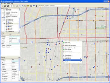
HydroDaVE Explorer is an interactive, web-based Windows application that combines GIS capabilities and allows users to access an SQL database through an internet-connected computer. It supports the ESRI shapefile format and the free OpenStreetMap. Users can select specific monitoring stations (wells or surface water stations) and display them on top of high-resolution aerial photography with pan and zoom capabilities. GIS layers (ESRI shapefiles) can be imported and displayed as a background reference with read-only access to the shapefile attribute table.
Comments